mountain hike to the Lac de Pormenaz
Sunday, October 20th, 2013 @ 08:00
, Geneva
update 17 October: FULL
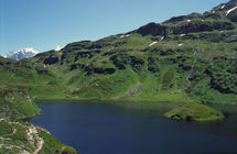
On 20 October, I will animate a hike to the Lac de Pormenaz, beyond Sallanches, about 65 km. from Geneva.
We will start from the parking above Le Mont near Servoz (981 m.) and follow the trail along the Souay torrent, through the forest. After the chalets du Souay, we continue direction Moede-Anterne and turn right to arrive at the Lac de Pormenaz (1945 m.) - pic-nic.
This is a circular hike - we will make our way back over a small, scenic path with real good views and then go down through the forest, to get back to the parking.
Gradient: about 1100 m., total distance about 12 km., time required for the climb: 2 ½ to 3 hours, the somewhat longer downhill will also take about 2 ½ hours. There are no technical difficulties, but as the hike is rather long you should have some mountain hiking experience.
The departure will be at 8h00 near the French-Swiss border. Common transport by cars (shared petrol costs, 13 Euro per passenger). Drivers are particularly welcome.
You will need enough food and drinks, warm and rainproof clothes, plus your passport and some euros, a backpack to put this all in, and your hiking shoes of course.
The hike is organised by the small hiking association Oxygene 74 http://rando-74.pagespro-orange.fr/. There is a participation fee of 5 Euros for a daily license of the French hiking federation FFRP, including insurance.
If you are interested to participate, drop me a line and let me know whether you will come by car.
cheers,
Bert
Talk
Please login to view or post comments


![[NYON] Au dessus du Ciel Beauty Center](https://buyclub.ch//_media/deals/5175_dl_photo_febaf.jpg)