Circular hike to Mont Charvin
Sunday, October 16th, 2016 @ 07:30
France voisine, Geneva
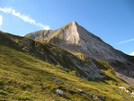
On September 12,2010 we enjoyed to climbing at Mont Charvin 2409 m.
I planned to repeat it one time agin On Sunday, October 16 before arriving the snow.
We start from Sous L’Aiguille 1180 m. (Manigod)
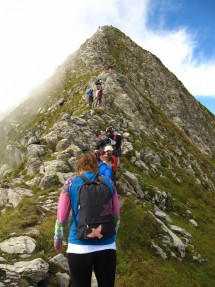
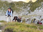
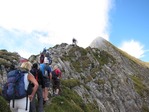
Via Chalet De L’Aulp De Fier D’En Haut, after cossing a rocky bar and some pastures we arrive at Lac Du Charvin. From here we walk on the East ridge to the summit.
Down to the Col De Porthets and via the West side, we arrive on the same trail where we have came.
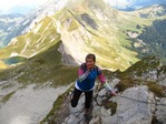
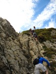
The route up from the lake, through the vertiginous ridge. This ridge is well secured with cable and chain.
Gradient gain 1250 m. Length 15 km.
For very experimented and sporty hikers, who don’t have vertigo.
Photos: https://goo.gl/photos/iPWQWjwKYcXgt19RA
We meet at Gaillard, behind the customs of Moellesullaz, in front of the Librairie de France at 7:30. Inscription is obligatory.
Equipment: Good mountain shoes, warm and waterproof clothes, glove, hat, helmet, drink, picnic ….
All must be prepared the day before.
The hike is organised by the small hiking association Oxygene 74
http://rando-74.assoc.pagespro-orange.fr
There is a participation fee of 5 Euro for a license of the French hiking federation FFRP, including insurance. Gas-sharing charges for those not driving of 0.10 euro-centimes per kilometer.
Formalities: The newcomers are asked to fill out the registration form
http://rando-74.assoc.pagespro-orange.fr/AdhesionEssayant-Oxygene74-2017.doc
and deliver it to the organizer on Sunday morning.
If you are interested, you can contact me by my direct e-mails [email protected]
You can also call me at 079 644 85 52 (only emergency)
I planned to repeat it one time agin On Sunday, October 16 before arriving the snow.
We start from Sous L’Aiguille 1180 m. (Manigod)
Via Chalet De L’Aulp De Fier D’En Haut, after cossing a rocky bar and some pastures we arrive at Lac Du Charvin. From here we walk on the East ridge to the summit.
Down to the Col De Porthets and via the West side, we arrive on the same trail where we have came.
The route up from the lake, through the vertiginous ridge. This ridge is well secured with cable and chain.
Gradient gain 1250 m. Length 15 km.
For very experimented and sporty hikers, who don’t have vertigo.
Photos: https://goo.gl/photos/iPWQWjwKYcXgt19RA
We meet at Gaillard, behind the customs of Moellesullaz, in front of the Librairie de France at 7:30. Inscription is obligatory.
Equipment: Good mountain shoes, warm and waterproof clothes, glove, hat, helmet, drink, picnic ….
All must be prepared the day before.
The hike is organised by the small hiking association Oxygene 74
http://rando-74.assoc.pagespro-orange.fr
There is a participation fee of 5 Euro for a license of the French hiking federation FFRP, including insurance. Gas-sharing charges for those not driving of 0.10 euro-centimes per kilometer.
Formalities: The newcomers are asked to fill out the registration form
http://rando-74.assoc.pagespro-orange.fr/AdhesionEssayant-Oxygene74-2017.doc
and deliver it to the organizer on Sunday morning.
If you are interested, you can contact me by my direct e-mails [email protected]
You can also call me at 079 644 85 52 (only emergency)
Talk
Please login to view or post comments