Hiking activity-la Berneuse
Saturday, June 19th, 2021 @ 08:00
, Lausanne
Hi all,
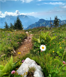
My plan is to go hiking from Leysin to Le berneuse. It's an excellent and safe hike with incredible views of mountains.
If you want to go by yourself, you may take a train or do car pulling together. In any case, meeting point will be Leysin Bahnhof. You may organise a meeting point, if you want to go by car together or take a train.
Alternatively, if someone wants to take a car, we may all go together from Lausanne.
Leave Lausanne at:8am
Meeting point : 9:30am Leysin train station, if you are coming by train
Parking place: in front of Leysin cable car stop - crossing of roads rue du commerce and les essert, near Route de Crettaz
Hiking time: 4.5 hours (both ways combined)
Leave for Lausanne from Leysin:3pm
What to bring: Water bottle, good hiking shoes, hat, poles (in case difficult to walk down), picnic, sun glasses and great mood and energy :)
Absolute elevation gain: 776m
Total length: 11km
Final destination altitude: 2048m
Difficulty level: Medium (Good fitness level required)
Please share your number so that I can add you to a WhatsApp group for our hike.
Talk
Please login to view or post comments


)