Crossing the Hauts Forts
Sunday, July 26th, 2020 @ 07:30
Haute-Savoie, Geneva
On Sunday, July 26, 2020 to please our eyes, we will cross the Hauts Forts, the highest peak of Chablais, dominates the entire region.
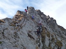
In the valley of Ardoise, we leave our cars on the parking the Covagnes. Go up to th Morzinette and Col du Pic à Talon, between Ressachaux and Hauts Forts. From this area we walk on the ridge to arrive at the summit.
Down by a steep edges, secured by the cable, to Creux de la Neige (Avoriaz). Get off to upper ski station (Plan Brazy 2275m) and via some sky pistes of Avoriaz, we arrive at Car park.
Elevation gain: 1300m. Length 16 km. There are the technical passages equipped by cables and ropes. For experienced and sporty hikers, who are not afraid of the emptiness below them.
Appointment:Appointment: 7:30 at Veyrier Douane, final stop of bus n° 8.
Equipment: Good mountain shoes, drink, warm and waterproof clothes, stick, gloves, cap. Etc…
Photos of our latest hike at this summit, October,11.2015: https://photos.app.goo.gl/FafuDPRjqBFcupKN9
We meet at Veyrier Douane, final stop of bus n° 8, at 7 :30. Inscription is obligatory.
The hike is organised by the small hiking association Oxygene 74 : https://rando-74.assoc.pagespro-orange.fr/index.htm
There is a participation fee of 5 Euro for a license of the French hiking federation FFRP, including insurance. Passengers in the vehicle pay directly to the driver € 0.10 per km.
Formalities: The newcomers are asked to fill out the registration form : https://rando-74.assoc.pagespro-orange.fr/AdhesionEssayant-Oxygene74-2020.doc
and deliver it to the organizer on Sunday morning.
If you are interested, you can contact me on my direct e-mails [email protected]. You can also call me (only emergency) at 079 644 85 52.
Please write me your mobil number and let me know if you will come with your car.
Talk
Please login to view or post comments


![[NYON] Au dessus du Ciel Beauty Center](https://buyclub.ch//_media/deals/5175_dl_photo_febaf.jpg)