Hike to Pointe de Blonnière
Sunday, November 14th, 2021 @ 07:30
Haute-Savoie, Geneva
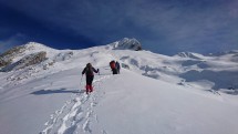
On Sunday, November 14,2021, with François we planned (if the weather is nice) to go to Pointe de Blonnière 2369 m. This summit hasn’t name on the IGN map , no or few used, is located in the Aravis Center, between Etale and Merdassier. Much of the route is wild or hasn’t trail. Normally it is a wintry course for ski touring …
We start from Comburce 1284 m (Manigod). Down by same way.
Elevation gain about 1100 m. Distance about 10 km. There is not major technical difficulties, but the route is very steep. So it is quite sporty.
For experimented and sporty hikers.
In case of bad weather on Sunday and nice on Saturday, this hike can be moved to Saturday. in case of snow we will take our snowshoes.
Photos :
Photos my first visit: https://photos.app.goo.gl/ZqRhTdi48K6XRAek6
3.7.2016: https://photos.app.goo.gl/HUVU9p4e7YmZBovH8
Our later hike to this summit: https://photos.app.goo.gl/RFVqaYC9ftC4TPxP9
We meet at Veyrier Douane, final stop of bus n° 8 at Veyrier Douane at 7:30. Inscription is obligatory.
Equipment: Good mountain shoes, hat, gloves, warm-cold and waterproof clothes, gaiter, stick, picnic, drink ….
Formalities: The newcomers are asked to fill out the registration form :
https://tinyurl.com/hphv7dds
and deliver it to organizer on Sunday morning.
The hike is organised by the small hiking association Oxygen 74
https://rando-74.pagesperso-orange.fr
There is a participation fee of 5 Euro for a daily license of the French hiking federation FFRP.
Passengers in the vehicle pay directly to the driver € 0.10 per km.
If you are interested, you can contact me on my direct e-mails [email protected].
You can also call me (only emergency) at 079 644 85 52.
Do let me know whether you will come by car and if you are an Oxygène member.
Write me please your mobile number and your e-mail address.
Talk
Please login to view or post comments